Latitude – Latitude is the angular distance of a place north or south of the Equator, measured in degrees (°), Minutes(‘) & second(“).It is the angle that shows how far a place is north or south from the Equator on Earth.
Latitude Lines – Latitude lines are imaginary horizontal lines drawn around the Earth parallel to the Equator that indicate different latitudes and help locate positions north or south of the Equator
Significance of latitude lines
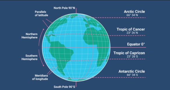
Latitude lines (parallels) are imaginary horizontal lines drawn around the Earth, running east–west, parallel to the Equator. Their significance lies in how they help us understand Earth’s location system, climate, and time patterns.
- They are also called parallels because they run parallel to the Equator.
- The distance between two lines of latitude is equal everywhere, about 111 kilometers and the distance between two latitudes is called a Zones.
- Lines of latitude help us to locate the position of a place on the Earth.
- The total number of latitude lines is 179.
- The heat zones, pressure belts, and climatic zones of the Earth are determined with the help of lines of latitude.
- As the angular value of latitude increases, the amount of sunlight received decreases. This is because when we move from the Equator toward the poles, the Sun’s rays become slanting and have to travel a longer distance, so less heat reaches the Earth poles compared to the Equator.
Types of Latitude lines
There are five main types of lines of latitude on the Earth:
- (Equator) – 0°
- It is the longest line of latitude.
- It divides the Earth into the Northern Hemisphere and Southern Hemisphere.
- (Tropic of Cancer) – 23½° North
- The Sun shines directly overhead on this line on 21 June.
- It marks the northern limit of the torrid zone.
- (Tropic of Capricorn) – 23½° South
- The Sun shines directly overhead on this line on 22 December.
- It marks the southern limit of the torrid zone.
- Arctic line – 66½° North
- Areas north of this line experience at least one day of 24-hour daylight in summer.
- It marks the northern frigid zone.
- Antarctic line – 66½° South
- Areas south of this line experience at least one day of 24-hour darkness in winter.
- It marks the southern frigid zone.
Note: Why are major lines of latitude taken at multiples of 23½°? – Because the Earth is tilted by 23½°, the Sun’s rays can move only up to 23½° north and south, so the major latitude lines are based on this angle and its related positions.
Temperature Zones of the Earth
The Earth does not receive the same amount of heat from the Sun everywhere. Because of this uneven heating, different parts of the Earth experience different temperatures. To understand this variation, geographers have classified the Earth into temperature zones. There are two main types of classification: Ancient classification and Modern classification.
Ancient Classification of Temperature Zones
The ancient classification was given by Greek scholars, especially Aristotle, based on their observations. At that time, scientific instruments and world travel were very limited. Scholars noticed that:
- The region near the Equator was extremely hot
- The regions near the North and South Poles were extremely cold
- The areas between these regions had a moderate climate
The Earth is divided into three main temperature (heat) zones based on the amount of sunlight received:
- Torrid Zone
- Located between 23½° N (Tropic of Cancer) and 23½° S (Tropic of Capricorn)
- Receives direct Sun rays
- Hottest region of the Earth
- Temperate Zones
- Located between 23½° and 66½° in both hemispheres
- Receive slanting Sun rays
- Have moderate temperature
- Divided into:
- North Temperate Zone
- South Temperate Zone
- Frigid Zones
- Located between 66½° and 90° near the poles
- Receive very slanting Sun rays
- Coldest regions of the Earth
- Divided into:
- North Frigid Zone
- South Frigid Zone
Ancient scholars believed that:
- The Torrid Zone was uninhabitable due to extreme heat
- The Frigid Zones were uninhabitable due to extreme cold
- Only the Temperate Zones were suitable for human life
These ideas were formed because of limited knowledge, lack of exploration, and restricted scientific understanding.
Modern Classification of Temperature Zones
With the development of science, technology, and exploration, geographers gained a better understanding of the Earth’s climate. Modern classification is based on scientific facts, especially the tilt of the Earth’s axis and the angle of the Sun’s rays.
Modern geographers explained that:
- The Earth is tilted at 23½°, which affects the distribution of sunlight
- Temperature varies with latitude, altitude, winds, ocean currents, and seasons
- Human beings can live in all temperature zones, including tropical and polar regions
The Earth is divided into different temperature zones based on the amount of heat received from the Sun.
1. Torrid Zone or Tropical zone
This zone lies between 23½° North (Tropic of Cancer) and 23½° South (Tropic of Capricorn).
The Sun’s rays fall directly on this region during the year, so it receives maximum heat.
As a result, it is the hottest zone of the Earth.
2. Sub-tropical Zone
This zone is found just outside the Torrid Zone, between the 23½° and 45° hot and temperate regions.
It experiences hot summers and mild winters.
The climate here is moderately hot, not extreme.
3. Temperate Zone
This zone lies between 45° and 66½° in both the Northern and Southern Hemispheres.
The Sun’s rays fall slantingly, so the temperature is moderate.
This zone experiences distinct seasons such as summer and winter and is suitable for human settlement.
4. Frigid Zone
This zone lies between 66½° and 90° near the North and South Poles.
The Sun’s rays are highly slanting, so very little heat is received.
As a result, this is the coldest zone of the Earth, with snow and ice for most of the year.
The ancient classification of temperature zones was based on observation and belief, while the modern classification is based on scientific understanding. Modern classification gives a clearer and more accurate explanation of the Earth’s temperature pattern and shows that all parts of the Earth can support human life.
Taiga and Tundra: Cold Climate Vegetation Zones
The Taiga vegetation is mainly found between 50°N and 70°N latitude, just below the Arctic Circle. It is dominated by coniferous trees like spruce, pine, fir, and larch, which are adapted to cold winters, short summers, and moderate rainfall. These trees are evergreen and have needle-like leaves to reduce water loss, helping them survive the long, harsh winters typical of this latitude range.
The Tundra vegetation lies north of the Taiga, above 70°N latitude, near the Arctic Circle and polar regions. Due to extremely cold temperatures, permafrost, and short growing seasons, trees cannot grow here. The vegetation is limited to mosses, lichens, grasses, and small shrubs, which can survive in the thin soil and harsh climate.
Note: The Taiga is found only in the Northern Hemisphere, while the Tundra exists in both hemispheres. This is because, between 50°–70° latitude in the Northern Hemisphere, there is extensive land, which supports the growth of dense forests, whereas in the Southern Hemisphere, these latitudes are mostly covered by oceans, preventing the development of similar forested regions.
Conclusion:
Latitude lines are imaginary horizontal lines that measure the distance north or south of the Equator and play a crucial role in determining climate, temperature, and daylight patterns across the Earth. They help divide the planet into tropical, temperate, and polar zones, influencing vegetation, animal life, and human activities. Understanding latitude is essential for geography, navigation, and studying the Earth’s ecosystems.


Pingback: Longitude & Longitude Lines – Learning Post