What is Longitude?
Longitude represents the angular distance of a place to the east or west of the Prime Meridian. It helps us identify the east–west position of any location on Earth. They are denoted in degrees (°), minutes (′), and seconds (″).
What are Longitude Lines?
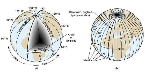
Longitude lines are imaginary vertical lines drawn on the globe that extend from the North Pole to the South Pole. These lines divide the Earth into eastern and western hemispheres.
Prime Meridian (0° Longitude)
The Prime Meridian is the reference line from which longitude is measured on the Earth. It passes through Greenwich in London, England, and is assigned a value of 0° longitude. The Prime Meridian divides the Earth into two equal halves—the Eastern Hemisphere and the Western Hemisphere—and serves as the foundation for locating places and calculating time across the world.
Why is the Greenwich Meridian Considered the Prime Meridian?
The Greenwich Meridian was accepted as the Prime Meridian (0° longitude) due to historical usage, scientific importance, and international agreement. In 1884, the International Meridian Conference held in Washington, D.C., with representatives from 25 countries, officially selected it to ensure uniformity in navigation, mapping, and timekeeping.
During the 18th and 19th centuries, Britain was the leading naval power, and most maps and navigation charts already used the Greenwich Meridian. The presence of the Royal Observatory at Greenwich, established in 1675, and the widespread use of Greenwich Mean Time (GMT) further strengthened its importance. Choosing Greenwich made time calculation easier and helped establish global time zones. Moreover, its relatively neutral geographic position and existing scientific data made it the most practical choice. Hence, the Greenwich Meridian is considered the Prime Meridian today.
Characteristics of Longitude Lines
Longitude lines have several important characteristics that help us understand the Earth’s position and time system:
- Longitude lines are imaginary lines drawn on maps and globes.
- They extend from the North Pole to the South Pole.
- Longitude lines are also called meridians.
- All longitude lines are equal in length.
- They meet at the poles and spread out the most at the Equator.
- Longitudes are measured in degrees east or west of the Prime Meridian (0°).
- There are 360 longitude lines in total. The maximum value of longitude is 180° East and 180° West.
- Longitude lines are used to calculate local time and determine time zones.
- All lines of longitude meet at the same point at both the poles.
- The distance between two longitude lines is called a “gore”
Importance of Longitude Lines
Longitude lines are important because they help us understand the position of places and the system of time on Earth. Their main importance is explained below:
1. Calculation of Time
Longitude lines help determine local time. Since the Earth rotates 360° in 24 hours, each 1° of longitude corresponds to 4 minutes. Places to the east are ahead in time, while places to the west are behind, because the Earth rotates from west to east. As a result, the Sun rises earlier in eastern regions and later in western regions.
Example: When it is 12:00 noon in Greenwich, it is 5:30 PM in India (east) and 7:00 AM in New York (west).
2. Basis of Time Zones
The world is divided into 24 time zones, each covering 15° of longitude, to maintain uniform time within a region. For example, Indian Standard Time (IST) is based on 82°30′E longitude. A country’s number of time zones depends on its east–west spread.
- Russia – 11 time zones
- USA – 6 time zones
- India and China – 1 time zone each, despite their size
3. Exact Location of Places
Longitude lines, along with latitude lines, help determine the precise location of any place on Earth. They are essential for maps, atlases, and GPS systems.
4. Navigation and Travel
Longitude lines are crucial for sea and air navigation. Sailors and pilots use them to determine direction, position, and route.
5. International Date Line
The 180° longitude forms the basis of the International Date Line (IDL), which maintains correct calendar dates worldwide.
6. Understanding Earth’s Rotation
Longitude lines help explain how the Earth’s rotation causes differences in time across various locations, linking geography with daily timekeeping.
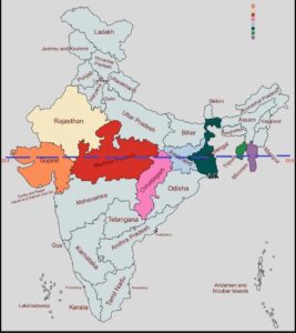
Longitude Lines in India
India extends approximately between 68° East and 97° East longitude, giving it a longitudinal spread of about 29°. Because of this wide east–west spread, there is a natural difference in the time of sunrise and sunset across the country. For example, the sun rises earlier in the eastern states like Arunachal Pradesh, while it rises later in the western states like Gujarat. If local time were followed, each state would have a different time, which would create confusion in daily activities, transportation, and administration.
To solve this problem, India follows a single standard time, called Indian Standard Time (IST). IST is based on the 82°30′ East longitude, which passes near Mirzapur in Uttar Pradesh. This central meridian is chosen so that the standard time represents a compromise between the eastern and western extremes of India.
International Date Line (IDL)
The International Date Line (IDL) is an imaginary line on the Earth’s surface that marks the transition from one calendar day to the next. It is closely linked to longitude and the Earth’s rotation, playing a vital role in timekeeping, global travel, and international coordination.
The IDL roughly follows the 180° longitude, passing mainly through the Pacific Ocean. It is not a straight line but zigzags around countries and islands to prevent splitting them into two different calendar days. It lies opposite the Prime Meridian (0° longitude) and serves as a reference for adjusting the calendar date when crossing longitudes.
The primary purpose of the IDL is to maintain a uniform calendar day worldwide. Since the Earth rotates from west to east, the sun rises earlier in the eastern regions, and without a date line, traveling across longitudes would create confusion in dates. When crossing the IDL from east to west, one adds a day, while crossing from west to east, one subtracts a day. For example, if it is Monday just west of the IDL, it becomes Tuesday immediately east of the IDL.
The IDL also works in coordination with time zones to ensure global consistency of time and date, preventing disruptions in communication, trade, and travel. Its zigzag shape ensures that entire countries, like Kiribati and Fiji, follow a single calendar day.
In summary, the International Date Line is crucial for maintaining calendar consistency, accurate timekeeping, and demonstrating the relationship between the Earth’s rotation, longitude, and global time.
This line is parallel to the Bering Strait, separating Alaska (USA) and eastern Siberia (Russia), while connecting the Arctic Ocean and the Bering Sea.
Longitude-Related Time Zone Issues in India
India does not have major conflicts over longitude lines per se, because longitudes are imaginary lines used mainly for mapping, navigation, and time calculation. However, there are issues related to time zones, which are linked to India’s longitudinal extent.
India spans approximately 68°E to 97°E longitude, giving it a wide east–west spread of about 29°. If local solar time were followed, the eastern and western parts of the country would have significantly different times. For example:
- The sun rises very early in Arunachal Pradesh (east)
- The sun rises much later in Gujarat (west)
To maintain uniformity, India uses one standard time—Indian Standard Time (IST)—based on 82°30′E longitude near Mirzapur, Uttar Pradesh.
This single time zone creates practical issues in the northeastern states, where there is a noticeable difference between sunrise and official time. People in the east often start work much earlier than the official time would suggest, leading to calls for a separate time zone for the northeast, sometimes referred to as “IST+1”.
So, the main “conflict” related to longitude lines in India is administrative and practical, not territorial. It revolves around the challenge of using a single standard time across a country with a wide longitudinal spread, balancing uniformity with local convenience.
Conclusion
Longitude lines play a crucial role in understanding the Earth’s geography, navigation, and time system. They help determine the east–west position of places, calculate local time, establish time zones, and guide navigation across the globe. The Prime Meridian at Greenwich and the International Date Line at 180° longitude provide standard references for global time and calendar management.
In India, the wide longitudinal spread makes it necessary to follow a single standard time (IST), balancing uniformity with local differences in sunrise and sunset. Overall, longitude lines are essential for accurate mapping, global coordination, and practical timekeeping, reflecting the close relationship between the Earth’s rotation, geography, and human activities.
Please Also see this – Latitude & Latitude Lines