Rivers are the backbone of India’s history, economy and civilization. From agriculture and transportation to religion and culture, Indian rivers have shaped the society for thousands of years. India has an extensive network of rivers originating from mountains, plateaus and hills, making the Indian River System one of the most diverse in the world.
The Indian River System mainly comprises two major categories:
- Himalayan Rivers
- Peninsular Rivers
Let us explore all major river systems in India one by one, in full elaborated form.
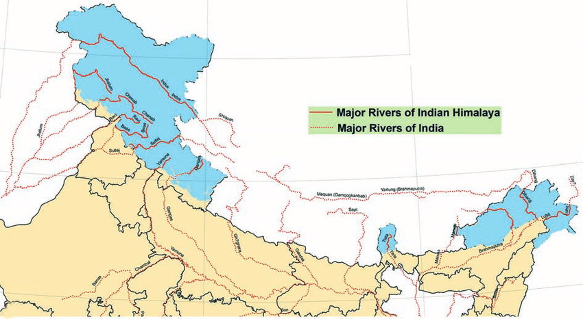
I. Himalayan River System (Perennial Rivers)
Himalayan rivers originate from glaciers of the Himalayas, so they carry water throughout the year. They are long, have high water volume, fertile plains, and create massive deltas.
The three major Himalayan river systems are:
- Indus River System
- Ganga River System
- Brahmaputra River System
1. The Indus River System – One of the World’s Largest
- Origin: Lake Manasarovar (Tibetan Plateau)
- Total Length: 3,180 km
- Length in India: 1,114 km
- Final Drainage: Arabian Sea
The Indus flows through Ladakh, Gilgit-Baltistan and Pakistan. It has a high volume of sediment and forms the famous Indus Plains, historically known for the Indus Valley Civilization (Harappa & Mohenjo-Daro).
Path: Lake Manasarovar → Tibet → enters India near Demchok (Ladakh) → flows through Leh → enters Pakistan → forms Indus Plain → drains into Arabian Sea.
Agriculture & Economy
The Indus river and its tributaries supply irrigation to:
- Punjab
- Haryana
- Rajasthan (via Indira Gandhi Canal)
This region is the largest wheat and rice producing zone in India, known as the Granary of India.
India–Pakistan Water Distribution
According to Indus Water Treaty (1960):
- Pakistan controls: Indus, Jhelum, Chenab
- India controls: Ravi, Beas, Sutlej
Tributaries of Indus (Extremely Detailed)
Jhelum River
- Origin: Verinag Spring (Jammu & Kashmir)
- Passes through: Srinagar → Wular Lake → Pakistan
- Known for: Houseboats, Dal Lake ecosystem, hydro projects
Chenab River
- Origin: Bara-Lacha Pass (Himachal Pradesh)
- Made from: Chandra + Bhaga → Chenab
- Known for: Deep gorges and strong flow → high hydropower potential
Ravi River
- Origin: Kullu Hills near Rohtang Pass
- Irrigation: Punjab & Himachal
- Famous battle site: Battle of Chillianwala
Beas River
- Origin: Rohtang Pass
- Cultural link: Sage Vyas meditated here
- Agriculture zone: Kangra & Punjab plains
Sutlej River
- Origin: Rakshastal Lake near Mansarovar (Tibet)
- Longest tributary of Indus
- Major dam: Bhakra–Nangal (India’s largest multi-purpose river project)
Major dams & hydropower projects on the Indus System (India)
| River | Project | Location |
|---|---|---|
| Indus | Nimu–Bazgo Dam | Ladakh |
| Indus | Chutak Hydroelectric Plant | Ladakh |
| Jhelum | Kishanganga Dam | J&K |
| Chenab | Baglihar Dam | J&K |
| Chenab | Salal Dam | J&K |
| Ravi | Ranjit Sagar Dam | Punjab |
| Beas | Pong Dam | Himachal Pradesh |
| Sutlej | Bhakra–Nangal Dam | Himachal & Punjab |
2. The Ganga River System
- Origin: Gangotri Glacier (Uttarakhand) → Known as Bhagirathi
- Length: 2,525 km
- End Point: Bay of Bengal
The Ganga flows through Uttarakhand, Uttar Pradesh, Bihar, Jharkhand and West Bengal, making it the longest and most sacred river in India.
Major Tributaries of Ganga (Expanded)
Yamuna — Biggest tributary
- Origin: Yamunotri Glacier
- Major cities: Delhi, Mathura, Agra
- Famous structures: Taj Mahal stands on Yamuna bank
Ghaghara
- Origin: Tibetan Himalayas
- High water-carrying capacity
- Disaster-prone monsoon floods
Gandak
- Origin: Nepal Himalayas
- Deposits very fertile alluvial soil
Kosi — “Sorrow of Bihar”
- Heavy deposition of silt leads to frequent change of course → repeated floods
Son
- Origin: Amarkantak Plateau
- Known for India’s longest river bridge in Patna
Damodar
- Known as “Rur of India” due to floods
- Location of major coal & steel industries (Dhanbad, Bokaro)
Major Dams & Hydropower Projects on the Ganga System (India)
Dams & Hydropower Projects on the Main Ganga River
| Dam/Project | State | Type | Purpose |
|---|---|---|---|
| Tehri Dam | Uttarakhand | Hydro + Storage | Power generation, irrigation & drinking water |
| Koteshwar Dam | Uttarakhand | Hydroelectric | Regulates water for Tehri Dam |
| Bijnor Barrage | Uttar Pradesh | Barrage | Irrigation & canal water control |
| Narora Barrage | Uttar Pradesh | Barrage | Supply to Lower Ganga Canal |
| Farakka Barrage | West Bengal | Barrage | Maintain navigation at Kolkata port & water regulation |
Yamuna River (Major Ganga Tributary)
| Dam/Project | State | Purpose |
|---|---|---|
| Hathni Kund (Tajewala) Barrage | Haryana | Irrigation & canal water |
| Wazirabad Barrage | Delhi | Water supply for Delhi |
| Okhla Barrage | Delhi | Water regulation |
| Dakpathar Dam | Uttarakhand | Hydropower & diversion |
| Asan Barrage | Uttarakhand | Hydropower & water sports |
Ramganga River
| Dam/Project | State | Purpose |
|---|---|---|
| Ramganga Dam (Kalagarh Dam) | Uttarakhand | Irrigation, hydropower & flood control |
Ghaghara River
| Dam/Project | State | Purpose |
|---|---|---|
| Girija Barrage / Upper Ghaghara Barrage | Uttar Pradesh | Irrigation |
| Khatria Dam (proposed) | Uttar Pradesh | Irrigation & flood control |
Gandak River
| Dam/Project | State | Purpose |
|---|---|---|
| Gandak Barrage (Valmikinagar Barrage) | Bihar | Irrigation (India & Nepal) |
Kosi River (Known as ‘Sorrow of Bihar’ due to floods)
| Dam/Project | State | Purpose |
|---|---|---|
| Kosi Barrage | Bihar (near Nepal border) | Flood control & irrigation |
| Upper Kosi Hydropower Project | Uttarakhand | Hydropower |
Son River
| Dam/Project | State | Purpose |
|---|---|---|
| Rihand Dam (Govind Ballabh Pant Sagar) | Uttar Pradesh | Hydropower & irrigation |
| Bansagar Dam | Madhya Pradesh | Hydropower & irrigation |
Important Hydropower Projects in the Ganga Basin (Uttarakhand Focus)
| Hydropower Project | River | Capacity |
|---|---|---|
| Tehri HPP | Ganga/Bhagirathi | 1000 MW |
| Tehri PSP (Pumped Storage) | Ganga | 1000 MW |
| Koteshwar HPP | Ganga | 400 MW |
| Maneri Bhali I & II | Bhagirathi | 304 MW |
| Vishnugad Pipalkoti HEP | Alaknanda | 444 MW |
| Tapovan Vishnugad HEP | Dhauliganga | 520 MW |
| Koldam (though on Satluj — part of Ganga power grid) | Himachal Pradesh | 800 MW |
3. Brahmaputra River System
Names and where it’s called what
Yarlung Tsangpo — the Brahmaputra’s name in the Tibetan Plateau (its uppermost course).
Dihang / Siang — the name used as it enters India in Arunachal Pradesh (local names vary along its upper course).
Brahmaputra — the common name in Assam (India).
Jamuna (or Jamuna/ Jamuna/ Jamuna river) — the major channel name used in Bangladesh for the Brahmaputra’s main stem; in Bangladesh it later meets the Ganges/Padma and the Meghna in a complex delta before emptying into the Bay of Bengal.
Origin and upper course (Tibet → the great gorge)
The Brahmaputra River originates on the Tibetan Plateau as the Yarlung Tsangpo and flows east before taking a dramatic turn around the eastern Himalaya. It then cuts one of the world’s deepest gorges, forming a steep and powerful mountain river with strong erosive force. After leaving Tibet, it enters India through Arunachal Pradesh, where it is called the Dihang or Siang. The river receives major tributaries like the Lohit and Dibang, after which it is known as the Brahmaputra. In the Assam Valley, it becomes a wide, braided river with shifting channels and many river islands.
Major tributaries (important contributors)
Key tributaries that join the Brahmaputra (on its entry through India and in Assam) include:
- Lohit — enters from the east (greatly influenced by monsoon rainfall and steep catchments).
- Dibang — drains the high-rainfall Arunachal ranges.
- Subansiri — a major western tributary with large flood peaks; has significant hydropower potential.
- Manas — drains Bhutan and north Assam; part of a UNESCO biosphere reserve and national park system.
- Dhansiri, Kopili, Jiadhal, Buri Dihing — other important tributaries that contribute flow and sediment.
(These tributaries supply both enormous water volumes during the monsoon and large quantities of silt and coarse sediment.)
Existing / Under-Construction Dams & Hydropower Projects
In Tibet / Upper Course (China)
Zangmu Dam
The Zangmu Dam is a major gravity dam built on the Yarlung Tsangpo in Tibet. It became fully operational around 2015 and has an installed power generation capacity of approximately 510 MW. It is considered one of the first large-scale hydropower projects on the upper Brahmaputra.
Jiacha Hydropower Station
Located on the middle reaches of the Yarlung Tsangpo, the Jiacha Hydropower Station plays a key role in regional energy production. It has an estimated capacity of around 360 MW, contributing significantly to Tibet’s electricity grid.
Dagu Hydropower Station
The Dagu Hydropower Station is another major dam on the Yarlung Tsangpo. Recently completed, it has a reported generation capacity of about 660 MW, making it one of the larger hydro projects in the region.
Yarlung Tsangpo Lower Reaches Hydropower Project
This project, currently proposed and under strategic planning, is among the most ambitious hydropower developments in the world. Often referred to as a “mega-dam” or “cascade project”, it is expected to have a massive installed capacity of approximately 60,000 MW when completed. Beyond power generation, the project holds significant geopolitical and environmental implications, raising concerns for downstream regions, including India and Bangladesh.
Major Dams & Hydropower Projects in the Brahmaputra River Basin (India)
| Dam / Project | River / Tributary / Basin | Status / Capacity / Notes |
|---|---|---|
| Subansiri Lower Hydroelectric Project (Lower Subansiri Dam) | Subansiri River (major tributary of the Brahmaputra) | Under construction. Once completed, it will have an estimated capacity of around 2,000 MW. |
| Ranganadi Hydroelectric Project | Ranganadi River sub-basin, Arunachal Pradesh | Completed and fully functional hydropower project. |
| Kopili Hydroelectric Project | Kopili tributary (Assam–Meghalaya region) | Operational hydropower project supplying power to the Northeast. |
| Doyang Hydroelectric Project | Doyang sub-basin (Nagaland / connected to Brahmaputra basin) | Completed and functional hydro project contributing to regional electricity. |
| Karbi Langpi Dam | Borpani River, Assam (part of the Brahmaputra basin system) | Completed hydropower project generating electricity for Assam. |
Apart from these major projects, there are many small and medium hydropower installations across the Brahmaputra basin on several tributaries. These projects highlight the significant dependence on the Brahmaputra river system for electricity generation and water resource management in Northeast India.
Conclusion — Himalayan River System
The Himalayan River System is one of the world’s most powerful and life-sustaining freshwater networks. Originating from the snow-covered peaks of the Himalayas, these rivers — including the Indus, Ganga, and Brahmaputra — shape the geography, ecology, culture, and economy of South Asia. They provide fertile soil, drinking water, hydroelectric power, irrigation, and support for millions of people and countless ecosystems.
Despite their immense benefits, the rivers also present challenges such as floods, soil erosion, and climate-change-driven glacial melt. Therefore, sustainable management of water resources, ecological conservation, and responsible development are essential. Protecting the Himalayan River System means securing the future of biodiversity, agriculture, and human livelihoods across the region
Please review this for the second part – The Indian River System – Peninsular River