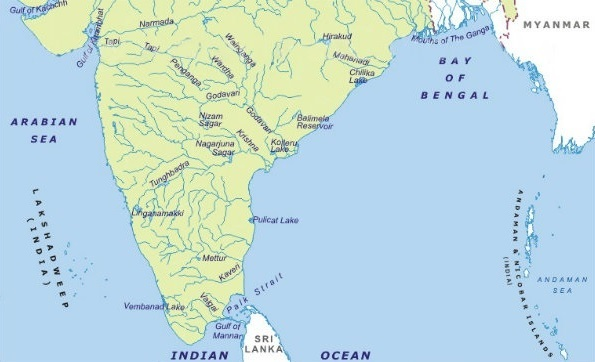
Peninsular River System of India
The Peninsular River System is one of the two major river systems of India and plays a vital role in shaping the geography, agriculture and water resources of the southern part of the country. Unlike the Himalayan rivers which are snow-fed, Peninsular rivers are mainly rain-fed and depend highly on the monsoon season. Most of them flow eastward into the Bay of Bengal, forming fertile deltas, while the Narmada and Tapi are the only major rivers that flow westward into the Arabian Sea.
In this article, we will discuss the key characteristics of Peninsular rivers, and explain every major river — Godavari, Krishna, Kaveri, Narmada, Tapi and Mahanadi — in simple and detailed language.
Key Features of the Peninsular River System
- Ancient and stable rivers flowing over hard and rocky terrain
- Mostly seasonal due to heavy dependence on rainfall
- East-flowing trend due to the slope of the Deccan Plateau
- West-flowing exceptions: Narmada and Tapi
- Widely used for irrigation, drinking water and hydro-projects
- Form broad deltas and fertile agricultural plains near their mouths
Major Rivers of the Peninsular River System
1. Godavari River – “Dakshin Ganga” / “Ganga of the South”
The Godavari is the longest Peninsular river, originating from Nashik in Maharashtra and flowing about 1,465 km across Maharashtra, Telangana and Andhra Pradesh before draining into the Bay of Bengal.
Major tributaries include Manjira, Penganga, Indravati and Sabari.
Godavari forms a wide and highly fertile delta that supports extensive agriculture. It is one of the most important freshwater sources for irrigation and drinking water in South India.
Tributaries of the Godavari River — Origin, Importance & Key Projects
| Tributary / River | Origin (State / Region) | Importance | Major Dams / Hydropower / Irrigation Projects |
|---|---|---|---|
| Manjira | Balaghat Range, Maharashtra | Provides irrigation & drinking water to Maharashtra, Karnataka & Telangana | Singur Dam, Nizam Sagar Project, Manjeera Barrage |
| Penganga | Ajanta Hills, Maharashtra | Supports agriculture in Vidarbha & Telangana basin | Upper Penganga Project, Lower Penganga Irrigation Project |
| Indravati | Dandakaranya Range, Odisha | Largest tributary by water volume; supports hydropower & tribal agriculture | Indravati Hydroelectric Project (1000 MW) |
| Pranahita (formed by Wardha + Wainganga) | Maharashtra | High water discharge; essential for large-scale irrigation | Pranahita–Chevella Lift Irrigation Project |
| Sabari | Eastern Ghats, Odisha | Supports paddy cultivation & tribal belt settlements in Odisha–AP border | Chitrakonda (Balimela) Hydroelectric Project (360 MW) |
| Wainganga | Mahadev Hills, Madhya Pradesh | Lifeline of eastern Vidarbha agriculture | Gosikhurd Dam |
| Wardha | Satpura Range, Madhya Pradesh | Supports cotton-growing belt of Maharashtra | Upper Wardha Dam |
| Kadva | Trimbakeshwar Range, Maharashtra | Supplies irrigation to northern Maharashtra | Kadva Dam Catchment Irrigation Works |
Major Hydropower & Dam Projects on the Godavari River (Mainstream)
| Project / Dam Name | State | Type / Purpose |
|---|---|---|
| Polavaram Project | Andhra Pradesh | Multi-purpose: irrigation + hydropower + drinking water |
| Sriram Sagar (Pochampad) Project | Telangana | Irrigation + drinking water supply |
| Jayakwadi Dam | Maharashtra | Irrigation + drinking water + inland fisheries |
| Dowleswaram Barrage (Sir Arthur Cotton Barrage) | Andhra Pradesh | Irrigation regulation + delta management |
| Gangapur Dam | Maharashtra | Drinking water supply + irrigation around Nashik |
| Bhandardara Dam (Pravara / Upper Godavari Project) | Maharashtra | Hydropower + irrigation |
2. Krishna River
The Krishna River is one of the longest and most important Peninsular rivers of India. It originates from Mahabaleshwar in Maharashtra and flows for about 1,400 km across Maharashtra, Karnataka, Telangana and Andhra Pradesh before draining into the Bay of Bengal.
The Krishna River forms a fertile basin that supports sugarcane, paddy, cotton and horticulture, making it one of the most agriculturally productive regions of India. The river and its tributaries are also vital for irrigation, hydropower, drinking water and fisheries.
Tributaries of Krishna River – Origin & Importance
Below is a table showing the major tributaries of the Krishna River, their origin and importance:
| Tributary | Origin (Region / State) | Importance |
|---|---|---|
| Koyna | Western Ghats, Maharashtra | Major source of hydropower, supports irrigation in western Maharashtra |
| Bhima | Bhimashankar Hills, Maharashtra | Lifeline of western Maharashtra and north Karnataka agriculture |
| Tungabhadra (formed by Tunga + Bhadra) | Western Ghats, Karnataka | Supports irrigation, drinking water & numerous ancient cultural sites |
| Ghataprabha | Western Ghats, Karnataka | Supports irrigation for sugarcane & vegetable cultivation |
| Malaprabha | Western Ghats, Karnataka | Supplies water to dams, canals & farming settlements |
| Musi | Ananthagiri Hills, Telangana | Provides water for agriculture and urban water supply around Hyderabad |
| Yerla | Satara District, Maharashtra | Supports local irrigation and groundwater recharge |
| Panchganga | Sahyadri Hills, Maharashtra | Supports sugarcane industries and fertile agricultural belts |
Importance of Krishna Tributaries
Increase seasonal water volume in the lower Krishna Basin
Support irrigation for millions of hectares of farmland
Act as major drinking water sources for rural and urban settlements
Enable hydropower production and dam-based water storage
Help maintain fisheries, navigation and basin ecology
Major Dams & Hydropower Projects on the Krishna River
The Krishna basin has several multi-purpose dams, reservoirs and hydropower stations that support agriculture and electricity generation.
| Dam / Hydropower Project Name | State | Purpose |
|---|---|---|
| Nagarjuna Sagar Dam | Telangana & Andhra Pradesh | Irrigation + drinking water + hydropower |
| Srisailam Dam | Andhra Pradesh | Hydropower + irrigation + flood control |
| Almatti Dam | Karnataka | Irrigation + hydropower + water regulation |
| Koyna Hydroelectric Project (Koyna Dam) | Maharashtra | One of India’s largest hydropower projects |
| Dhom Dam | Maharashtra | Irrigation + drinking water supply |
| Ujjani Dam (Bhima River) | Maharashtra | Irrigation + drinking water + fisheries |
| Ghataprabha Reservoir (Hidkal Dam) | Karnataka | Irrigation + canal network |
| Malaprabha Dam (Navilatirtha Dam) | Karnataka | Irrigation + water supply |
| Jurala Project | Telangana | Irrigation + hydropower |
| Pulichintala Project | Andhra Pradesh | Flood control + irrigation + water storage |
3. Kaveri River
The Cauvery (Kaveri) River is one of the most sacred and economically significant rivers of South India.
It originates from Talakaveri in the Brahmagiri Hills of Karnataka, flows for about 800 km through Karnataka and Tamil Nadu, and finally drains into the Bay of Bengal.
The Cauvery delta is considered one of the most fertile agricultural regions in India, leading to the river being popularly called the “Ganga of the South”. The river plays a crucial role in rice cultivation, drinking water supply, hydropower generation, and irrigation across the southern states.
Tributaries of the Cauvery River — Origin, Importance & Key Benefits
| Tributary | Origin (State / Region) | Importance | Key Benefits / Projects |
|---|---|---|---|
| Hemavati | Western Ghats, Karnataka | Major contributor to Cauvery water volume in Karnataka | Hemavathi Reservoir, irrigation to Hassan, Tumkur & Mysuru regions |
| Kabini | Wayanad Hills, Kerala | Supports agriculture, forests and wildlife habitats in Karnataka | Kabini Reservoir, drinking & irrigation water to Mysuru |
| Amaravati | Anamalai Hills, Tamil Nadu | Lifeline for agriculture in Karur, Tirupur & surrounding areas | Amaravathi Dam, irrigation & fisheries |
| Bhavani | Nilgiri Hills, Tamil Nadu | Supports fertile plains in Erode district | Bhavani Sagar Dam, canal irrigation |
| Noyyal | Western Ghats, Tamil Nadu | Supplies water to Coimbatore region | Irrigation tanks and urban water distribution |
| Arkavati | Nandi Hills, Karnataka | Supports Bengaluru rural belt agriculture | Reservoirs & groundwater recharge systems |
These tributaries boost the water availability of the Cauvery River and enable large-scale agricultural production in Karnataka and Tamil Nadu.
Major Dams & Hydropower Projects on the Cauvery River (Main Channel)
| Dam / Project Name | State | Purpose / Importance |
|---|---|---|
| Krishna Raja Sagara (KRS) Dam | Karnataka | Irrigation + drinking water supply to Bengaluru & Mysuru |
| Mettur Dam (Stanley Reservoir) | Tamil Nadu | Major irrigation for Cauvery Delta + hydropower |
| Lower Mettur Hydroelectric Project | Tamil Nadu | Electricity generation |
| Civic Hydroelectric Plant (Shivanasamudra) | Karnataka | One of India’s earliest hydroelectric projects |
| Harangi Dam | Karnataka | Irrigation + drinking water |
| Kodiveri Dam | Tamil Nadu | Agriculture support for Erode region |
4. Narmada River
The Narmada River, also known as the “Life Line of Madhya Pradesh and Gujarat”, is one of India’s most significant west-flowing rivers. Originating from Amarkantak Plateau in Madhya Pradesh, the river stretches for around 1,312 km and flows through Madhya Pradesh, Maharashtra and Gujarat before emptying into the Arabian Sea.
Flowing between the Vindhya Range (north) and the Satpura Range (south), the Narmada forms breathtaking gorges, valleys and waterfalls — including the famous Marble Rocks of Jabalpur and Dhuandhar Falls. It is one of the most important freshwater sources for irrigation, drinking water and hydroelectric power in Central India.
Tributaries of the Narmada River & Their Importance
The Narmada has several major tributaries that enhance its water volume and regional importance.
| Tributary / River | Origin (State / Region) | Importance |
|---|---|---|
| Tawa | Satpura Range, Madhya Pradesh | Supports irrigation and drinking water in Hoshangabad and Betul region |
| Banjar | Mandla District, Madhya Pradesh | Helps agriculture and forest areas in eastern MP |
| Hiran | Amarkantak Region, MP | Supports wildlife sanctuaries and agriculture around Jabalpur |
| Shakkar | Sagar District, MP | Irrigation support for paddy and wheat belt |
| Dudhi | Seoni Hills, MP | Provides water to tribal and forest regions |
| Kolar | Betul Region, MP | Supplies drinking water and irrigation to nearby districts |
| Orsang | Maharashtra / Gujarat border | Supports river basin agriculture in Gujarat |
| Karjan | Satpura Hills | Important for Karjan Dam hydropower and irrigation |
Major Dams & Hydropower Projects on the Narmada River
The Narmada is one of India’s most dammed rivers and plays a key role in water storage, irrigation and electricity generation.
| Dam / Project Name | State | Purpose / Importance |
|---|---|---|
| Sardar Sarovar Dam | Gujarat | One of India’s largest multipurpose projects — irrigation, hydropower (≈1,450 MW), drinking water |
| Indira Sagar Dam | Madhya Pradesh | Major hydropower project (1,000 MW) + irrigation |
| Omkareshwar Dam | Madhya Pradesh | Hydropower (520 MW) + irrigation |
| Maheshwar Dam | Madhya Pradesh | Hydroelectric project (400 MW) |
| Bargi Dam | Madhya Pradesh | Irrigation, flood control & drinking water supply |
| Tawa Dam (on tributary Tawa) | Madhya Pradesh | Supports agriculture & drinking water for Hoshangabad division |
| Karjan Dam (on tributary Karjan) | Gujarat | Hydropower + irrigation support to tribal belt |
4. Tapi (Tapti) River
The Tapi (Tapti) River is one of the three major west-flowing rivers in India, along with the Narmada and Luni. It originates near Multai in the Satpura Range, Madhya Pradesh, and travels about 724 km through Madhya Pradesh, Maharashtra and Gujarat before draining into the Gulf of Khambhat (Arabian Sea).
Flowing almost parallel to the Narmada, the Tapi plays a crucial role in sustaining western and central India, especially Khandesh region, Surat, and industrial belts of Maharashtra and Gujarat. The river supports agriculture, fisheries, drinking water supply and several major irrigation and hydroelectric projects.
Tributaries of the Tapi River & Their Importance
| Tributary / River | Origin (State / Region) | Importance |
|---|---|---|
| Purna | Betul District, Madhya Pradesh | Major water source for irrigation in Khandesh (Jalgaon & Burhanpur) |
| Girna | Western Ghats, Maharashtra | Supports sugarcane belt and horticulture in Nashik & Jalgaon |
| Panjar | Satpura Hills, Maharashtra | Helps agriculture in Amravati and Akola districts |
| Mosi | Betul Hills, Madhya Pradesh | Supplies water to tribal and rural settlements |
| Vaki | Satpura Range | Contributes to local irrigation and groundwater recharge |
| Bori | Satpura Range | Water supply source for Betul and surrounding agriculture |
| Arna | Maharashtra | Seasonal water inflow supporting local farming |
These tributaries collectively enhance the Tapi’s water availability and ensure sustained agricultural productivity across the basin.
Major Dams & Hydropower Projects on the Tapi River
The Tapi River basin hosts several multipurpose dams that supply irrigation water, hydropower and drinking water.
| Dam / Project Name | State | Purpose / Importance |
|---|---|---|
| Ukai Dam (Vallabh Sagar) | Gujarat | One of India’s largest multipurpose projects — irrigation, flood control, power generation & drinking water |
| Kakrapar Weir / Kakrapar Dam | Gujarat | Controls irrigation water flow & provides drinking water to Surat region |
| Hatnur Dam | Maharashtra | Irrigation and drinking water support for Jalgaon and nearby districts |
| Girna Dam (on Girna tributary) | Maharashtra | Major irrigation project supporting sugarcane cultivation |
| Purna Dam (on Purna tributary) | Maharashtra | Provides water for agriculture and industry in Khandesh |
| Waghur Dam | Maharashtra | Supplies power and water to Jalgaon region |
| Suki Dam (on Mosam–Tapi basin) | Maharashtra | Irrigation and drought relief support |
| Ukai Hydropower Project | Gujarat | Generates significant electricity for the western grid |
6. Mahanadi River
The Mahanadi River is one of the most important east-flowing rivers of Peninsular India. It originates from the Sihawa Hills in Chhattisgarh and travels around 858 km through Chhattisgarh and Odisha before forming a wide delta and finally draining into the Bay of Bengal.
Known as the “Rice Bowl River of East-Central India”, the Mahanadi supports dense agricultural settlements and provides drinking water, irrigation and electricity to millions of people.
Tributaries of the Mahanadi River & Their Importance
| Tributary / River | Origin (State / Region) | Importance |
|---|---|---|
| Seonath (Sheonath) | Chilpi Range, Chhattisgarh | Largest tributary, provides irrigation and supports industries |
| Hasdeo | Chhota Nagpur Plateau, Chhattisgarh | Coal belt river; supports power plants and agriculture |
| Mand | Surguja Hills, Chhattisgarh | Major contributor to water volume; important for tribal agriculture |
| Arpa | Bilaspur District, Chhattisgarh | Local irrigation and drinking water source |
| Jonk | Odisha–Chhattisgarh Border | Supports paddy cultivation in western Odisha |
| Ib | Hills of Odisha | Supports industries and power generation in Jharsuguda belt |
| Ong | Odisha | Enhances agricultural productivity in Bargarh–Balangir belt |
| Tel | Odisha | Major tributary aiding irrigation and groundwater recharge |
The vast tributary network makes the Mahanadi Basin one of India’s most water-rich agricultural zones.
Major Dams & Hydropower Projects on the Mahanadi River
| Project / Dam Name | State | Purpose / Importance |
|---|---|---|
| Hirakud Dam | Odisha | One of the world’s longest earthen dams; irrigation + flood control + power generation |
| Ravishankar Sagar (Gangrel Dam) | Chhattisgarh | Drinking water + irrigation + hydropower |
| Hasdeo Bango Dam (on Hasdeo tributary) | Chhattisgarh | Hydropower + industrial & agricultural water supply |
| Dudhawa Dam | Chhattisgarh | Irrigation support for central Chhattisgarh |
| Mahanadi Barrage (Jobra Barrage) | Odisha | Water regulation + drinking water supply for Cuttack & coastal settlements |
| Mand–Seonath Irrigation Projects | Chhattisgarh | Enhances agricultural productivity in rice zones |
| Hirakud Hydropower Project | Odisha | Generates significant power for Odisha & eastern grid |
| Upper Jonk Dam | Odisha | Irrigation and rural water supply |
These projects ensure flood control, irrigation, drinking water distribution and continuous power supply across the basin.
Conclusion
The Peninsular Rivers of India form an essential component of the country’s physical and economic landscape. Originating mostly in the Western Ghats and Central Highlands, these rivers flow across the Southern Plateau before draining into the Bay of Bengal and the Arabian Sea. While Godavari, Krishna, Kaveri, and Mahanadi are major east-flowing rivers, the Narmada and Tapi stand out as the two significant west-flowing rivers.
These river systems support agriculture, irrigation, hydropower generation, inland fisheries, navigation, and drinking water supply, turning the river basins into some of the most productive regions of India. Deltas like the Cauvery and Mahanadi are among the country’s most fertile areas, while vast multipurpose projects such as Polavaram, Hirakud, Ukai and Sardar Sarovar have transformed regional economies.
Overall, the Peninsular Rivers are not just geographic features — they are lifelines that sustain millions of people and shape India’s socio-economic development. Sustainable river management, conservation of water resources, and ecological balance are crucial to ensure that these rivers continue to nurture future generations.
Please see the First Part for Better Understanding- The Indian River System


Pingback: The Indian River System – Learning Post