The Tropic of Cancer is an important geographical line that plays a key role in dividing India into two almost equal halves. It is an imaginary latitude line situated at approximately 23.5° North of the Equator. This line represents the northernmost point on Earth where the sun can appear directly overhead at noon, which occurs during the summer solstice around June 21 every year. Its passage through India significantly influences the country’s climate, seasons, and agricultural patterns.
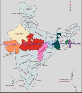
In India, the Tropic of Cancer passes through eight states, starting from the west and moving eastward. These states are:
- Gujarat – It enters India near the Gulf of Khambhat and passes through Kutch and other regions.
- Rajasthan – Crosses districts such as Udaipur and Banswara.
- Madhya Pradesh – Passes near Bhopal, the state’s capital.
- Chhattisgarh – Cuts across districts like Ambikapur.
- Jharkhand – Passes close to Ranchi, which lies almost exactly on the line.
- West Bengal – Moves through Krishnanagar and other regions.
- Tripura – Passes through the southern part of the state.
- Mizoram – Finally exits India through this northeastern state.
The Tropic of Cancer divides India into two distinct climatic zones. The region south of the line experiences a tropical climate, characterized by high temperatures and heavy rainfall, while the region north of it has a subtropical climate, with cooler winters and moderate summers. This division affects not only temperature and weather but also agriculture, as different crops are grown in the two zones based on climate conditions.
Overall, the Tropic of Cancer serves as a natural boundary influencing India’s day length, sunlight intensity, monsoon patterns, and biodiversity, making it one of the most significant latitudinal lines in the country.